


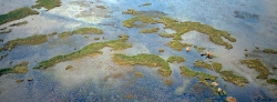

163_LZmL_133 Bangweulu aerial
Image information
Description
| Title: | LZmL_133 - Bangweulu aerial, Lake Bangweulu, N Zambia |
| Caption: | Fishing communities build seasonal camps on the floating vegetation on Lake Bangweulu. The name 'Bangweulu' translates as "Where the Land meets Sky" or "Where the Water Meets Sky", referring to the vast expanse of lakes and wetlands that form Lake Bangweulu and the Bangweulu swamps. The open water lake and the swamps combine to extend over a huge area of some 15,000 sq.km., and form the Upper Congo River Basin on Zambia's plateau lands, at an altitude of over 1100m. The Bangweulu lake and wetlands hold the waters of the Chambeshi River and Chambeshi Flats (flood plain). The many drifting, vegetation-clogged channels hold the immense volume of water back such that it drains only slowly from its southern end to form the Luapula River. These waters are the source of the Congo River. |
| Edition: | Signed Limited Edition of: 100 |
| Print: | Panoramic fine art print on various media & in various sizes - see Price List for options. |
| Price: | PRICE CODE 1 - LINK TO PRICE LIST - click on link to open Price List in a new tab. |
| Stock: | Available to order - CONTACT or direct email to wildfoto(at)wildfotoafrica.com Worldwide delivery available. |